Each map has a story to tell – of changing boundaries and the cartographers viewpoint. An ongoing exhibition in the city presents a selection of such 100 maps from pre-independence India.
Titled ‘India: A Mapful Story’ the exhibition has on display unseen historical maps and other important engravings dating back to the 18th century, up to 1946. Printed in England, France, Italy and the USA, the show features maps by cartographers like Seutter, Rennell, Mortier, Lapie, Bonne and Tallis.
Cartography is the art of graphically representing a geographical area. As an art, it was at its zenith in 17th-19th centuries as explorers discovered more places and were also able to mark their exact geographical locations with the help of longitudes and latitudes. During that time, there was a vast commissioning of maps by the western powers.
It also serves as an important tool to understand the changing geographical boundaries and the possible reasons behind them. This collection focuses on map of Pre-independence India when it represented present day India, Pakistan and Bangladesh.
“The exhibition presents cartographic works from spanning a period of 350 years. The display does not follow a chronological sequence; it’s very possible that the two works displayed next to each other are actually two or three centuries apart,” says Anubhav Nath, Director, Ojas Art.
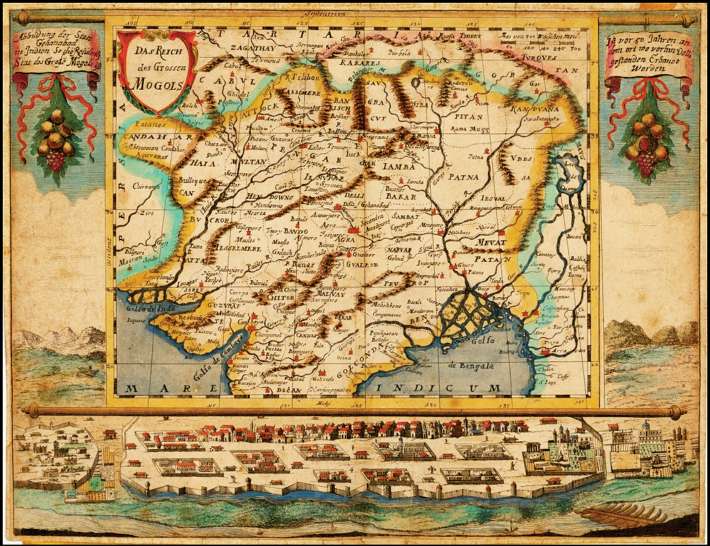
One of the most interesting map on display is the 1689 Wagner map of Mughals which shows the Mughal territories and has a rare view of the Red Fort in Delhi. The Mughal Emperor Shah Jahan announced the building of the Red Fort in 1639, which was completed in 1648 and the Mughal capital was shifted to Delhi. The building spacing is very accurate though some shapes have gone wrong. But Diwan-e- aam and Diwan-e-khaas are clearly identifiable.
The three cartouches in German on the top of the map are very significant and give a lot of information. The top left corner cartouche translates as “Illustration of the state Shahjahanabad in India – the residence of the Grand Mogols”, followed by the center cartouche which reads, “The Empire of the Great Mughals”.
Finally, the right cartouche reads, “50 years ago in the place 100 before Delhi had been built.” On further understanding, one may decipher “100” is a typo error – it basically translates from old German as – “50 years ago in this place, Delhi was built”.
Another insightful map of 1865 India and South East Asia by A.J Johnson, offers colour coding according to countries as well as notations regarding roadways, cities and river systems. The map covers from the Indus River eastward to include all of India, Burma, Siam (Thailand), Laos, Cambodia, Malaysia, Vietnam and also parts of Pakistan, China and Bangladesh.
So drop in to understand how the boundaries of the Indian continent has changed over the years through maps.
The exhibition is on display at Ojas Art Gallery till January 8
Five police teams are conducting raids across Delhi-NCR and Haryana to trace the absconding Delhi…
Domestic bullion prices declined sharply on Tuesday, with gold falling Rs 700 per 10 grams…
The MCD has notified more than 1,300 heritage structures, including historic havelis and other old…
Two juveniles were apprehended after allegedly breaking into a church in Pitampura and stealing brass…
Four held for operating a mule bank account network used in a Rs 2.47 lakh…
The Delhi government is planning to raise four dedicated SDRF battalions to strengthen disaster response,…
