Thick into the monsoons, several states are facing flood alerts and reeling under heavy rainfall, wreaking houses, disrupting public transport and halting normal lives.
While in Eastern India, Chhattisgarh and Odisha are constantly monitoring the weather reports as Mahanadi river swiftly swelling to dangerous mark, heavy rains have lashed Mumbai in the western part of the country. Meanwhile, a light drizzle is predicted in Delhi.
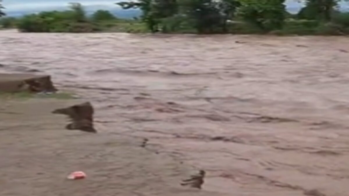
Flood alert in Odisha, Chhattisgarh as Mahanadi swells after incessant rain
Bracing for a possible flood-like situation in several districts, the Odisha government has closed eight more gates in the Hirakud reservoir as more water is entering into it due to heavy rainfall in the upper catchment areas in Chhattisgarh. With the water level of the Mahanadi river swiftly rising following heavy rain in the catchment areas over the last few days, efforts are on to deal with the circumstances.
Torrential rain in the upper and lower catchment areas has led to the rise in water levels in all tributaries of the Mahanadi.
The situation has deteriorated with the Tel river discharging over three lakh cusecs into the Mahanadi river instead of the expected 1.5 lakh cusecs, the government said.
At 6 pm on Monday, 10.41 lakh cusecs of water was flowing through the barrage and the volume is likely to increase further.
Special instructions have been issued to officials of Cuttack, Jagatsinghpur, Kendrapara and Puri districts to remain prepared for any eventuality. Though no major river embankments have been breached, incessant rain has already inundated several areas in Sambalpur, Bargarh, Subarnapur, Boudh, Kandhamal and Cuttack districts, officials said.
The meteorological department in its latest bulletin said extremely heavy rain of over 204 mm pounded parts of Kalahandi, Kandhamal, Koraput, Nabarangpur and Sambalpur till 8.30 am on Monday.
Meanwhile, Chhattisgarh Chief Minister Bhupesh Baghel on Monday asked the administration to monitor the situation in Janjgir-Champa and Raigarh districts due to continuous rise in the water level of the Mahanadi river amid heavy rains and the process of shifting people from low-lying areas along the major river to relief camps had begun as a precautionary measure.
Several districts in Chhattisgarh have received heavy rainfall since Saturday evening, resulting in rise in water level of rivers like Mahanadi, Shivnath and Indravati as well as flooding of villages in low-lying areas
Balodabazar received 82.4 millimetres of rainfall, Dantewada 63.1 mm, Mahasamund 65.2 mm, Janjgir-Champa 65.1 mm, Bastar 55.9 mm, Raigarh 52.7 mm, Narayanpur 47.4 mm, Bilapur 42.4 mm, Raipur 36.6 mm and Bijapur got 36.5mm between Saturday evening and Sunday morning, they said.
In Korba district, several roads have been cut off due to heavy rainfall that resulted in nullahs (major drains) and rivulets in Pali area overflowing, while Barsoor-Chitrakot road in Dantewada has been disrupted as water was flowing above the culvert on Mandher rivulet, officials informed.
Meanwhile, the Raipur Meteorological Centre, in the afternoon, said Bastar, Dantewada, Narayanpur, Kanker, Gariaband, Dhamtari, Bilaspur, Korba, Mahasamund, Raipur, Balodabazar and Sukma would witness heavy rainfall in the next 24 hours.
As per the state revenue department, average rainfall of 814.9 mm has been recorded in Chhattisgarh till Saturday since June 1 this year. The highest rainfall of 1814.9 mm was recorded in Bijapur district while Surguja district witnessed the lowest average rainfall of 330.7 mm during this period.
At least 64 people have died in rain-related incidents and other natural calamities between June 1 and August 13 in the state, mainly due to heavy rains in the southern and central regions, the revenue and disaster management department revealed.
Of the 64 monsoon-related deaths, 36 died in lightning strikes, 22 due to drowning and six from snake bites
Heavy rain in Mumbai
Mumbai witnessed heavy showers on Tuesday as the rain intensity increased in the city after a gap of a few days.
The weather department has predicted occasional intense rain spells in the city in the next 24 hours.
According to civic officials, there was no report so far of any major water-logging in low-lying areas. Trains and bus services of the Brihanmumbai Electric Supply and Transport (BEST) were running normally, they said.
Early in the morning, there was either no rain or light showers in most parts of the city.The heavy downpour started around 10 am, they said.
Between 10 am and 11 am, Parel and Dadar received 14 mm rainfall, while Malabar Hill and Nair Hospital areas received 19 mm rain, a civic official said.
In the eastern suburbs, 12 mm rainfall was recorded at the Vikhroli fire station and 11 mm at Chembur fire station during the same period, while the Malvani fire station and Chincholi fire station in western suburbs recorded 22 mm and 20 mm rain.
The Meteorological department has predicted a generally cloudy sky with moderate rain in the city and suburbs with a possibility of occasional intense spells for the next 24 hours.
The city recorded 7.91 mm rainfall in the 24 hour-period till 8 am on Wednesday, while the eastern and western suburbs recorded 12.94 mm and 12.33 mm rainfall, respectively, another civic official said.
There will be a high tide of 4.39 metres in the Arabian Sea here at 2.57 pm, the official said.
The rain intensity had reduced in Mumbai over the last few days when most parts of the city received light showers.
Light rain likely in Delhi
The minimum temperature rose by a few notches in the city on Tuesday to settle at 27 degrees Celsius, even as the weather office forecast cloudy sky with light rain later in the day.
The city recorded a relative humidity of 74 per cent at 8:30 AM, according to data shared by the India Meteorological Department (IMD).
The minimum temperature on Monday was recorded at 25.8 degrees Celsius, a notch below the season’s average, while the maximum temperature was recorded at 34.9 degrees Celsius, a notch above normal.
Parts of the national capital received traces of rainfall on Monday morning.
The minimum temperature in the national capital on Tuesday was recorded at 27 degrees Celsius.
The MeT Office has forecast generally cloudy sky with light rain later in the day on Tuesday, with the maximum temperature expected to settle around 34 degrees Celsius.
The minimum and maximum temperature readings on Wednesday are likely to settle at 26 degrees Celsius and 35 degrees Celsius respectively, according to the IMD forecast.
The air quality index (AQI) of Delhi was recorded in the satisfactory (57) category around 9:15 AM, data from the CPCB showed.
An AQI between zero and 50 is considered good, 51 and 100 satisfactory, 101 and 200 moderate, 201 and 300 poor, 301 and 400 very poor, and 401 and 500 severe.
Flash floods in Himachal Pradesh
A search operation was launched at Solang Nala in Kullu after two people went missing following flash floods on Monday. Search and rescue operations, that stopped due to the increase of water flow in the river, resumed on Tuesday morning.
Deputy Commissioner Kullu, Ashutosh Garg had earlier told news agency ANI, “A temporary bridge has been reported to be washed away by the flow of water in the Solang area of Manali. Some people were also crossing this bridge when the accident took place. As per eyewitnesses two people drowned in the drain and the authorities are trying to recover the body of one of the deceased.”
Jammu and Kashmir
Flood-like situation in Ujh river in Kathua district as massive amount of water flow ferociously due to heavy rainfall in hilly terrains of the region.