When you come out of a fancy Metro station and encounter traffic chaos, you wonder whether the city has any concern for pedestrians at all
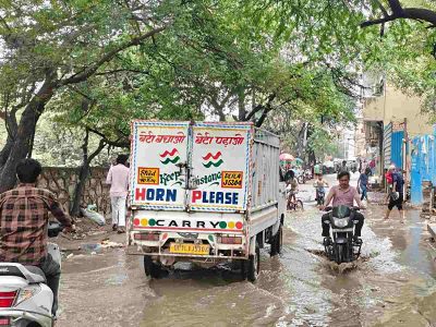
Choked traffic, jampacked lanes and garbage at every corner — three things make Vikas Marg stand out among Delhi’s main roads. While the street name suggests ‘development’, the nightmarish scenario for pedestrians in East Delhi seems to be a result of poor planning and poorer execution.
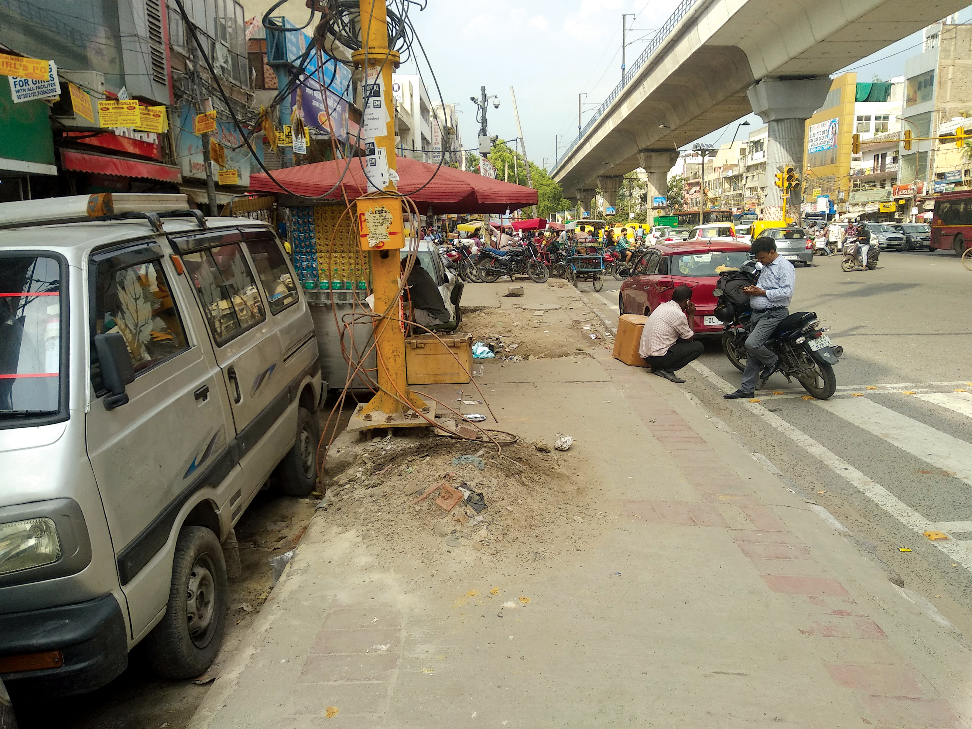
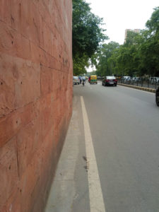
As commuters get down from Gate No. 1 at Laxmi Nagar Metro Station to go to their respective destinations, suddenly comes a shocker — no path to walk. So what do they do?
On your left, traffic speeds past as the signal turns green, so you try save yourself. On your right, the whole street is dominated by rickshawalas waiting for customers and bike riders zigzagging to get ahead. Who is to be blamed for this chaos?
Besides conducting encroachment drives, not much has been done for the Capital city’s pedestrian infrastructure.
According to a DDA data, as many as 34% of all daily person trips are ‘walk-only’— with 58% of education trips and 31% of business and service trips being walking trips. Almost 50% of metro users travel to/from the stations on foot. Walking is also the dominant mode of travel for 77% of the urban poor who commute on foot. Additionally, almost 60% of all trips are less than 4km and 80% below 6km – an ideal distance for using non-motorised modes like walking and cycling. Absence of adequate pedestrian infrastructure – almost 40% of road length has no footpaths (basic walking infrastructure).
As per a traffic police study, of the 1,510 people who died in road accidents in 2017, at least 44% were pedestrians. In 2018, of the 1,604 people who were killed in road accidents, about 40% of them were pedestrians. The situation in Laxmi Nagar provides a testimony to these facts. An area which is a hub — of coaching institutes catering to students for banking services, chartered accountancy and several other exams.
The land adjacent to the Metro pillars, is regularly filled with cycle-rickshaws, occupying almost half the lane. While the parked vehicles of the shops and coaching centres opposite the station, occupying the rest.
For Shikha Singh the area “seems like a total mess.” A student who has settled in the nearby Nirman Vihar area — to prepare for chartered accountancy exams. Singh regularly travels by Metro, gets down at Gate No. 1 and goes to a coaching centre in the lane.
“You should see the situation in the evening. Sometimes it feels like another Chandni Chowk. You are stuck while walking, because the bike driver wants to go first, the rickshawala wants to push ahead, everyone wants to overtake the other,” says Singh.
She continues, “You have to make yourself believe that it’s they who are in a hurry, not you. Only then one can survive coming to this area regularly.”
The owner of the cigarette stall next to the public toilet sees it all, day in and day out: “Evening mein toh bura haal ho jaata hai. Yahan koi footpath nahi hain. Gau, rickshaw, cycle, bike sab issi gali mein hi chalta hain” (It’s a mess during evening. There’s no footpath here. Cow, riskhaw, cycle and bike, everything is passing off through this one lane only).
Even if one decides to cover the whole stretch on foot, the continuous interruption caused by rickshaw riders and bike drivers makes it a tiresome exercise.
This is the situation in one part of Delhi, which sees countless number of pedestrians, where footpaths are a thing of the future. In contrast, Lutyens’ Zone projects another picture of the Capital city.
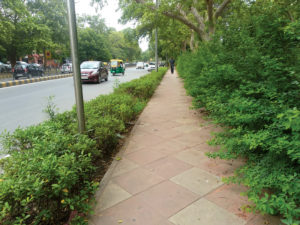
Here, the paths are encroachment-free, construction-free, and so to speak — human free. It won’t be wrong to say the sidewalks in Lutyens’ Delhi are swanky, and you never run the risk of stubbing your toe on a broken pavement or any other obstruction. They remain in top notch quality, because of the NDMC handling them since years.
Walking in Lutyens’ Delhi is a pleasant experience. You head for your destination on a sidewalk lined with flowers and plants under lush green trees on both sides. Unlike the rest of the areas of the Capital, the trees here are aligned in a straight line.
One could see white collar office-goers taking a comfortable stroll in lunch hours as traffic speeds past.
But some footpaths in the Lutyens’ zone also have major discrepancies. Take Janpath, originally called Queen’s Way, which has been an important part of Lutyens’ Delhi since the inauguration of new Capital of India in 1931.
There is a significant amount of encroachment on Janpath. Like in Laxmi Nagar, one could also experience a footpath ending abruptly, leaving you on the edge of the road — with hardy a foot or two from the life-threatening traffic.
Sarika Panda Bhatt, Head, Integrated Transport and Road Safety at World Resources Institute (WRI) says, “I think only 5% or 8% of the footpaths in Delhi are in walkable condition. It is mostly the NDMC area, otherwise there’s not a single footpath which is totally walkable.”
“When Dwarka was getting developed, they built footpaths. But now the maintenance is poor. Same with Rohini, it is totally encroached upon. Or Laxmi Nagar, where footpaths don’t even exist,” says Bhatt.
When new footpaths are constructed, what should be kept in mind? Bhatt says, “They should be continuous. There should not be any obstruction. If there’s a building line coming, pedestrian footpath would be at-grade and continuous.”
She does not think street vendors are such a problem. “They encroach on 10% of the footpath area. What about the 90%?” asks Bhatt.
She cites people extending their garden to pathways, putting up hoardings, growing trees and whatnot. But “the soft target is the street vendor. That’s the best they can do.”
“On one hand we’re talking about air pollution and then we’re talking about walking, cycling and promoting public transport. But whosoever is using mass transit system, they need to walk. If they can’t walk, then they won’t use the system,” points out Sarika.
Around the World
Keeping in mind that the urban share of the world’s population will increase to over 70% by 2050, The Institute for Transportation and Development Policy (ITDP) came up with a new tool to help governments, city planners, NGOs and developers make cities healthy and equitable.
Titled ‘Pedestrians First: Tools for a Walkable City’, it will facilitate the understanding and the measurement of the features that promote walkability in urban cities. “It comes with basics, checklists, examples and policy recommendations — to create an enjoyable walking environment in your city,” said Joe Chestnut, Research Associate at ITDP at the time of its launch.
ITDP’s new tool has 11 indicators for measuring walkability.
Walkability — to enhance complete, continuous and safe walkway networks that will provide better protection from motor vehicles. Also highlighting accessible to all people, including those with disabilities.
One example of this practice is in Liuyun Xiaoqu, Guangzhou, China which was a gated residential complex with its street clogged — and now has become car-free, having walkable corridors.
Crosswalks — These are necessary for the reason that they safely connect the walkway network across vehicular traffic and become a top priority for making walkable areas.
Visually Active Frontage — To promote safety from crime in walkable areas, by using informal observation and surveillance by people inside buildings. Often described as “eyes on the street.”
London’s Central Saint Giles development is one example of this. The development has exclusive restaurants, corporate apartments, luxury and affordable housing units. However, there’s very little parking available — only reserved for cycles.
Physically Permeable Frontage — Wherever there is continuous ground-floor activity and services have fewer zones of inactivity, hence, creating a more appealing walking environment which makes it safer from crime.
Shade and Shelter — To help make the walkable zones more comfortable and accessible by protecting pedestrians from heat, rain and other elements.
Small Blocks — Small blocks reduce trip distances, making walking more convenient for trips.
Prioritised Connectivity — To provide walking over motorised forms of transportation to improve walkability. Making it more convenient relative to other modes of transportation.
Complementary Uses — A mix of uses reduces the distance between homes and services, thereby improving access. Shorter trips are more likely to be done by walking.
Access to Local Services — If an area will have basic services within easy walking distance, then it will enable more of these trips by foot.
Driveway Density — An urban walking environment that reduces the locations where a pedestrian must cross the path of cars leads to a safer and more comfortable walking experience.
Roadway Area — Minimising the space given to motorised forms of transportation provides more space for walking infrastructure, such as sidewalks, and minimises car speeds and volumes, leading to a safer, more convenient walking environment.